
News and Events
Oct 13, 2022
How Luokung provides spatial-temporal “driving force” for global sustainable development
Sophisticated remote sensing satellite applications are reshaping the carbon neutrality and natural ecology management industries, with Luokung spatial-temporal big data technology at the heart of the revolution.
Global Sustainable Development Demands and the Outbreak of Remote Sensing Industry
In 2022, we all have experienced the large-scale extreme high temperature, floods and other natural disasters that remind us the importance of global sustainable development.
The United Nations issued "Transforming Our World: The 2030 Agenda for Sustainable Development" and systematically put forward 17 general goals involving dimensions of economy, society and environment,as a major leap for mankind's pursuit of a sustainable future. The importance of conservation and restoration of global terrestrial natural ecosystems is highlighted in the agenda.
Remote sensing satellite as an efficient and accurate earth observation and monitoring technology now is playing a vital part of terrestrial ecosystems conservation and restoration. Such explosion of usage generates massive image data continuously, which leads to a significant increase in demand of data processing and services. In 2021, the scale of the global satellite industry reached US$279 billion, of which the satellite services, as the midstream in the industry chain, accounted for 42.3% of the overall scale. In China, the innovation in satellite services also strongly supports the full-scale outbreak of the whole industry.
Why remote sensing satellite data processing matters to the industry
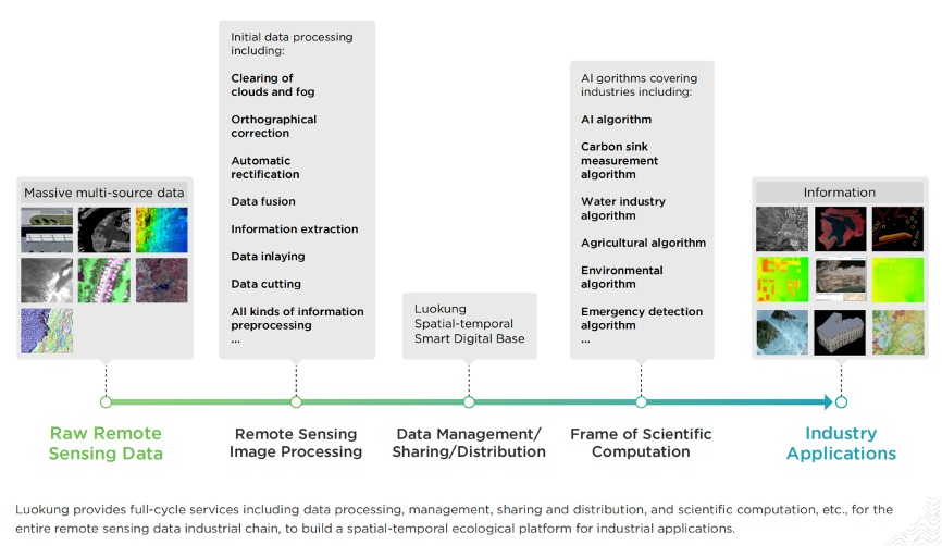
The upstream of remote sensing satellite industry involves satellite manufacturing, satellite launching, and ground equipment. Commercial satellite operations, data related technologies and services are categorized into the midstream that contributes core value to the industry by providing data-driven technologies, algorithms and services to the downstream. Capabilities to realize timely, integrated and comprehensive data processing embedded with disciplinary knowledge, AI algorithms and visual deep learning technologies, as determining factors of how well such data will be used in industry applications, are even more needed than ever.
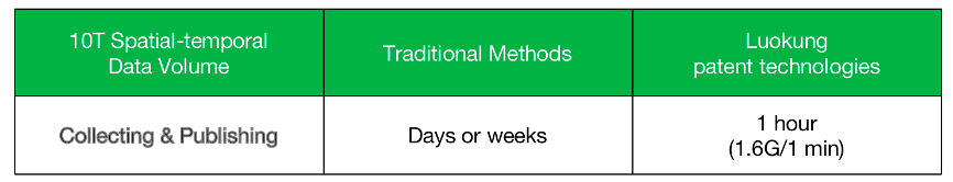
With the world’s leading spatial-temporal data indexing cloud and full vector non-tile patent technologies, Luokung realizes distinguished data distribution and management performance. Data collecting and publishing speed up to 10T/h that is equivalent to 10 scenes of GF1 multi-spectral, which is 100+fold faster compared with traditional methods.
Empowered by such cutting-edge data processing technologies, Luokung knocks down the using threshold for remote sensing data to actively expand the market share in rapid growing commercial aerospace industry.
Luokung Data Business Ecology
On the basis of powerful data processing capabilities, Luokung promoted a full sack of remote sensing oriented solutions including spatial-temporal data management platform, open cloud services and various industry applications.
By leveraging technological advantages of Luokung, the company’s operating affiliate, Luokung Remote Sensing Technology Co.,Ltd., is pioneer of carbon neutrality and natural resources asset management distinguished by it’s online multi-sourced remote sensing image data services, remote sensing AI analysis, and multi-industry SaaS-level applications. Currently, it has been serving numbers of fields including carbon sink monitoring, natural ecological monitoring, meteorological disaster warning, cultivated land protection, agricultural insurance, etc.
Moreover, through establishing the "Terrestrial Ecosystem Carbon Neutrality Joint Laboratory" together with Chinese Academy of Forestry, Luokung Remote Sensing Technology is devoted to promote the tight cooperation between industry, academia and research institutes to optimize related disciplinary knowledge, methodologies and AI algorithms, and create greater contribution for scientific research of sustainable development of terrestrial natural ecosystems.
Spatial-temporal data is paving the way of ecological sustainable development
·How Luokung Remote Sensing Technology measures carbon sink
With the open and extensible working platform embedded with original remote sensing image analysis AI algorithms, and forestry algorithm models, the Forestry Information Management System covering the whole business process is provided for forest carbon sink monitoring and measurement in region at all levels. According to the results, formal and certified reports will be conducted to further support the trading of carbon sink credits under CCER scheme.
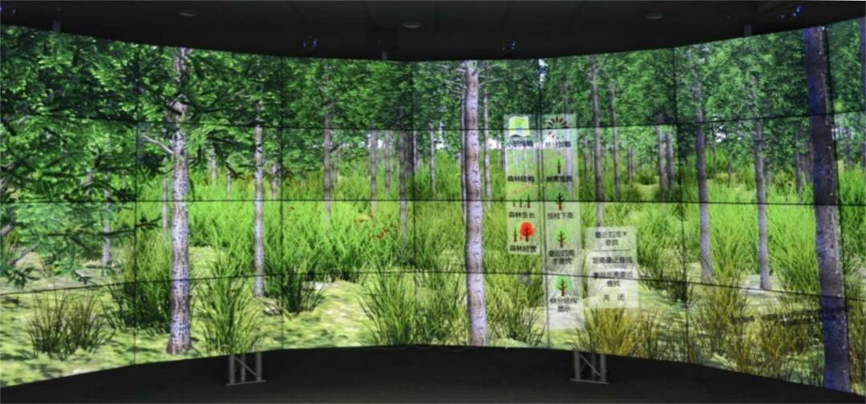
Realistic 3D forest
As we announced earlier this year, based on its own satellite remote sensing + lidar fusion technology, Luokung has established a "real three-dimensional forest" and completed the very first carbon sink measurement project in Jixi, Anhui Province. This is a showcase of technology superior of Luokung Remote Sensing Technology in carbon sink monitoring and measurement market.
·How Luokung supports terrestrial ecology sustainable development
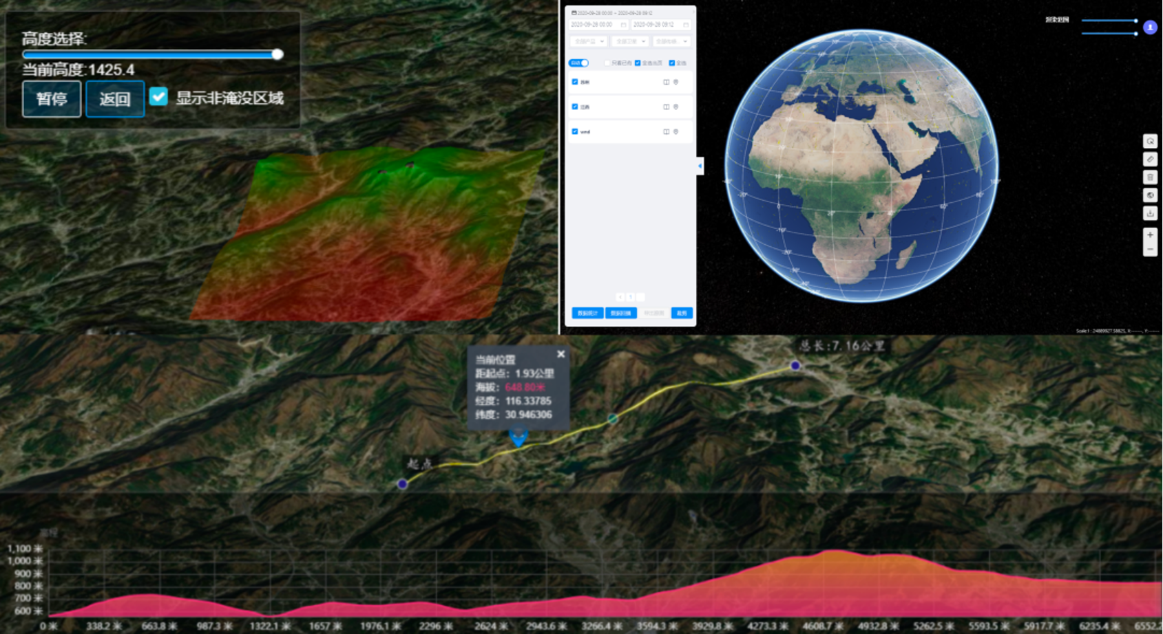
Terrestrial ecology smart management systems heavily rely on the fusion processing and visualized analysis of muti-sourced remote sensing data under long temporal sequence.
Luokung builds its modeling ability and digital intelligence and constructs a expendable multi-industry application service platform, the Digital Base, to comprehensively supports knowledge-based analysis, visual analysis, remote sensing intelligent interpretation services. It addresses issues of fusion processing and visualized analysis precisely thereby to provides more intelligent solutions for dynamic ecosystem monitoring, land use change monitoring and biodiversity conservation.
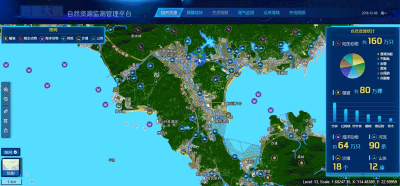
Luokung Smart Ecological Monitoring Platform
The terrestrial ecosystems provide human beings with raw materials for production and living, and is an necessary environment for human survival. However, promoting sustainable development of terrestrial ecosystems through satellite remote sensing and other diversified technologies is new and long-tem subject to all of us. Luokung deeply awares such urgency and necessity. By diving into today’s environmental challenges, we put constant efforts on spatial-temporal technologies innovation to participate actively in carbon net-zero and ecological environment governance,and importantly, to hold the ESG commitment we have made.