
News and Events
Nov 22, 2022
How Luokung creates application value for remote sensing image utilization
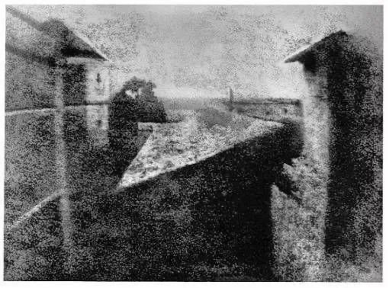
Initiated with the birth of photography
In 1826, the appearance of the world's first photo announced the birth of photography technology.
Photography technology enables people to preserve the scene of a specific time and a specific place in the form of photos. At the same time, humans cleverly realized that observation for more distant scenes is possible as long as to carry the camera on a higher platform and shoot from a distance.
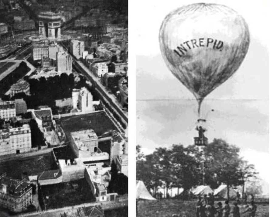
In 1858, the very first aerial photo was shot with the camera mounted on a hot air balloon by the French.
When the time came to the 1960s, the invention of the aeroplane surprisingly led to the development of modern remote sensing technology. Subsequently, the progress made in technologies of aerospace, electromagnetic wave, communication, etc. directly accelerated the rapid development and wide application of remote sensing, and it became an independent discipline officially in 1962.
The challenges of the remote sensing data services industry
Today, with the great strides made in the aerospace field, remote sensing technology, as a practical and advanced spacial detection technological means, provides all-weather and global coverage of earth observation capability, and is widely used in natural resource monitoring, climate change, environmental monitoring, disaster monitoring, urban planning, transportation, electric power, land using, forestry, agriculture, surveying and mapping, emergency response and other fields.
According to the data from Northern Sky Research (NSR), the total revenue of the global satellite remote sensing data market in 2022 is expected to reach 4.438 billion US dollars, of which the total revenue of remote sensing data value-added services and data information products is close to 3.2 billion US dollars. Governments, enterprises, and academic institutions are primary clients.
1) Massive data processing
Wildly expansion of remote sensing application scenarios has driven the rapid growth of the upstream market of the remote sensing industry. Taking the statistic released by the Satellite Application Center of the Ministry of Ecology and Environment of China as an example, there are 73,050 scenes of ecological environment remote sensing image produced (data volume 796TB), which reached a 236% increase compared to the year 2020. This is just one particular area of data from one acquisition platform among others. Massive volume of data produced on daily basis creates explosive demand for instantaneous and application-oriented value-added remote sensing data services.
2) multi-source heterogeneous data processing
We may think that today’s computing capability and intelligent technologies should be enough to deal with massive data processing. However, the characteristic of multi-source heterogeneity( multi-sensor, multi-resolution, multi-temporal, multi-element) brings huge challenges to general model training. In addition, remote sensing images can only be utilized after the interpretation process involving image correction, transformation, and classification to eliminate various radiation distortions and geometric distortions, which is far more complex than general image recognition. This dilemma results in heavy reliance on experts and aggravates the limit of efficient exploitation of remote sensing big data.
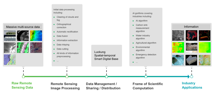
How Luokung establishes the integration cloud platform with comprehensive application value
With the spatial-temporal data indexing cloud, the full vector non-tile patent technologies, and the advanced digital base, Luokung realizes distinguished data distribution and management performance. Data collecting and publishing speed up to 10T/h which is equivalent to 10 scenes of GF1 multi-spectral, which is 100+fold faster compared with traditional methods. Timely general remote sensing products and services are provided through the cloud platform with a high frequency of data update, analysis, publishing and displaying up to every 15 minutes, which greatly reduces the threshold for data utilization and realizes on-demand, real-time cloud high-resolution data service.
The integrated full-process scenario-based cloud platform encompasses data management, scientific computation framework and industry applications. Based on the comprehensive integration of multi-source massive remote sensing data and various spatial-temporal data, AI image interpretation, and 2D & 3D display technology, multi-temporal aggregated image display supporting data query based on the geographic and temporal range is realized.
1)Natural Resource Management
By providing automated full-cycle data management and intelligent interpretation with trained AI algorithms for ecological elements recognition, classification, extraction and change detection, Luokung helps administration departments conduct dynamic ecosystem monitoring, ecological survey, red line warning, land use monitoring and forest carbon sink accounting.
2)Emergency Response
On top of data process and AI capabilities, the platform provides a scientific decision-making basis in disaster and rescue activities through designated area monitoring and section analysis.
3)Environmental Protection
Through remote sensing inversion and deep learning algorithms, realizing elements extraction, features classification, change detection and impact factors inversion of the target object for environment monitoring and management including water eutrophication detection, water pollution monitoring and mining area governance, etc.
4) Smart Agriculture
Based on the high-resolution remote sensing data, meteorological data, spectral features and vital growth-impacted factors of crops, an inversion model is established to realize agricultural-related meteorological disasters, crop pests and soil moisture monitoring.
Nowadays, remote sensing has become the most effective technology for earth observation. It has also gradually become a feasible means to cognize other celestial bodies. From walking upright, to the invention of wheels, now the remote sensing technology, human beings have never stopped in their steps to understand the world in a broader vision. Luokung believes, and will always be committed to paving the way to a broader, digitized and intelligent world with our spatial-temporal technologies.